Simulation of Sahel Rainfall by CMIP5 Models
CMIP5 datasets have been acquired from the Earth System Grid – Center for Enabling Technologies (ESG-CET) when made available as not all model output for all experiments are currently online and accessible. Prior to assessing the simulation of Sahel rainfall in decadal hindcasts, the representation of the climatology of precipitation and SST has been evaluated in the historical (20th century) coupled simulations in order to identify model biases and common errors in the simulation of current climate.
Spatial patterns of rainfall show similar features to observations across West Africa and the adjacent oceans across the multi-model ensemble. However, one important feature of the majority of the models is the southerly location of the rainfall maximum across the Atlantic and West Africa (similar to findings using the CMIP3 multi-model ensemble) during the summer. This southerly location of the rainfall maximum during summer, leads to an underestimation of rainfall in the Sahel in the majority of models (Fig. 1). As in the CMIP3 models, simulations in general overestimate rainfall during spring and underestimate during summer, as the monsoon rains do not penetrate far enough north.
Spatial patterns of rainfall show similar features to observations across West Africa and the adjacent oceans across the multi-model ensemble. However, one important feature of the majority of the models is the southerly location of the rainfall maximum across the Atlantic and West Africa (similar to findings using the CMIP3 multi-model ensemble) during the summer. This southerly location of the rainfall maximum during summer, leads to an underestimation of rainfall in the Sahel in the majority of models (Fig. 1). As in the CMIP3 models, simulations in general overestimate rainfall during spring and underestimate during summer, as the monsoon rains do not penetrate far enough north.
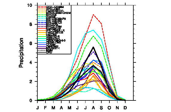
Figure 1: Annual cycle of Sahel (10°N – 20°N, 20°W - 10°E) rainfall from CRU observations (black line), individual ensemble mean historical CMIP5 simulations (colored lines) and the multi-model mean (black dotted line).
The errors in the rainfall structure and annual cycle can be explained in part by the incorrect simulation of SSTs in the historical CMIP5 simulations. Similar to previous generations of global climate model simulations, SSTs are too warm (with only one model being colder) in the Gulf of Guinea, particularly during summer. While there is some cold tongue development in the models, it is generally much weaker than observed, leading SSTs to be up to 4°C warmer than observed and the Sahel drier during the summer. Additional evaluation of coupled simulations would provide some insight into the mechanisms in the atmospheric model.
The importance of the Saharan heat low to the multidecadal variability of Sahel rainfall was shown in results from the AMO-Sahel rainfall connection. Hence, it is necessary to document the simulation (including structure, variability and associated circulations) of the heat low in the CMIP5 models.
The importance of the Saharan heat low to the multidecadal variability of Sahel rainfall was shown in results from the AMO-Sahel rainfall connection. Hence, it is necessary to document the simulation (including structure, variability and associated circulations) of the heat low in the CMIP5 models.
