The AMO - Sahel Rainfall Connection
A combination of observations (CRU and GPCP precipitation, HadISST sea surface temperatures) and reanalysis (NCEP/NCAR) was used to investigate the mechanisms of the connection between the Atlantic multidecadal oscillation (AMO) and Sahel rainfall. The summer rainfall increase over the Sahel during warm AMO years was observed as part of a dipole structure with the Guinea coast.
Unlike interannual variability, Gulf of Guinea sea surface temperatures (SSTs) are not forcing the dipole structure at multidecadal scales. The strengthening of the Saharan heat low and its associated cross equatorial shallow meridional overturning circulation during warm AMO years leads to the rainfall dipole, as shown in Fig. 1. The strengthening of the heat low is accompanied by increases in Mediterranean SSTs during warm AMO years that leads to increases in moisture and heat flux convergence in the Sahel. Increases in low-level westerly winds are observed during warm AMO years due to increases in the interhemispheric SST and sea level pressure gradients. These interhemispheric gradients dominate the rainfall enhancement over the ocean, and are supplemented by the shallow overturning circulation of the stronger heat low over land.
Unlike interannual variability, Gulf of Guinea sea surface temperatures (SSTs) are not forcing the dipole structure at multidecadal scales. The strengthening of the Saharan heat low and its associated cross equatorial shallow meridional overturning circulation during warm AMO years leads to the rainfall dipole, as shown in Fig. 1. The strengthening of the heat low is accompanied by increases in Mediterranean SSTs during warm AMO years that leads to increases in moisture and heat flux convergence in the Sahel. Increases in low-level westerly winds are observed during warm AMO years due to increases in the interhemispheric SST and sea level pressure gradients. These interhemispheric gradients dominate the rainfall enhancement over the ocean, and are supplemented by the shallow overturning circulation of the stronger heat low over land.
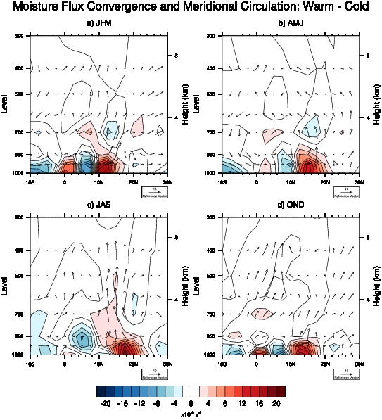
Figure 1: Meridional cross section (averaged between 20°W - 10°E) of the difference in moisture flux convergence (shading, s-1) and meridional circulation (vectors) between warm and cold AMO phases for a) JFM, b) AMJ, c) JAS and d) OND from NCEP/NCAR reanalysis.
During warm AMO years the African easterly jet (AEJ) is farther north and more unstable than in cold AMO years. This increased instability allows for an increase in African easterly wave (AEW) activity across West Africa and into the Atlantic, as shown in Fig. 2. This increased AEW activity, as measured by eddy kinetic energy, during periods when the AMO is in the warm phase may be contributing to decadal variations in Atlantic tropical storm activity, with increases observed during warm AMO years.
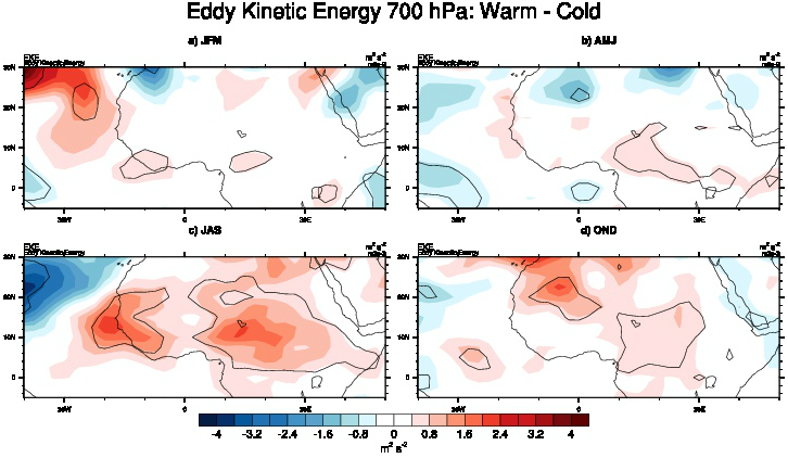
Figure 2. Difference in eddy kinetic energy (EKE) (m2s−2) between warm and cold AMO phases for a) JFM, b) AMJ, c) JAS and d) OND from four times daily NCEP/NCAR reanalysis (1948-2009). Black lines indicate regions where EKE in warm AMO and cold AMO years are statistically different from each other at the 95 % confidence level using a simple students t-test.
This methodology will be applied to CMIP5 model data and will provide a basis for comparison into mechanisms occurring in the models between the AMO, Mediterranean SSTs and Sahel rainfall.
